
Understanding The Connectivity: Distance From Sobha One World To Electronic City And Whitefield
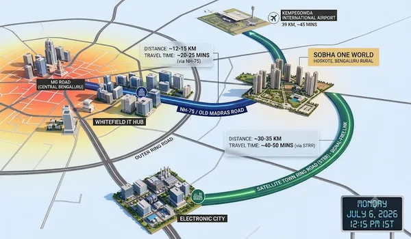
Understanding the connectivity and distance from Sobha One World to Electronic City and Whitefield highlights a highly strategic commute layout, with the 300-acre mega-township sitting exactly 11.6 to 12.3 kilometers (20 to 25 minutes) from the core Whitefield IT corridor and around 40 kilometers (50 to 55 minutes) from Electronic City via the smooth, access-controlled Satellite Town Ring Road (STRR) and Outer Ring Road (ORR) systems.
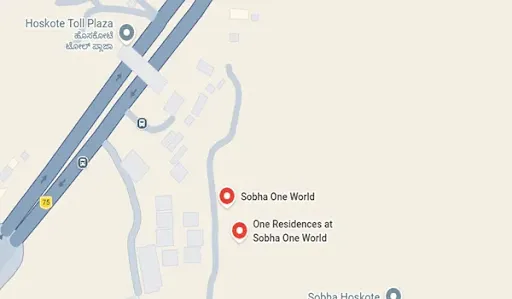
Tucked right behind the Hoskote Toll Plaza off Old Madras Road (NH-75), this massive residential development serves as a perfect transit bridge. For corporate employees and real estate investors in 2026, living here makes it easy to balance work travel to East and South Bangalore's major employment zones while enjoying a cleaner, low-density suburban lifestyle.
1. Navigating the Commute from Sobha One World to Whitefield
For the thousands of software professionals, data analysts, and tech executives working in East Bangalore, Sobha One World serves as a natural extension of Whitefield, often marketed under the "Greater Whitefield" umbrella:
- The Exact Distance: The physical gate-to-gate distance from the township to the International Tech Park Bangalore (ITPL) and the core EPIP Zone ranges between 11.3 km and 15.7 km.
- Travel Time Breakdown: During standard off-peak windows, the drive takes barely 18 to 20 minutes. During peak morning rush hours (8:30 AM to 10:00 AM), it stabilizes at a highly predictable 25 minutes via the NH-648 bypass.
- The Transit Advantage: Residents can skip inner city bottlenecks entirely. By moving smoothly down the Whitefield-Kadugodi road network, drivers bypass the heavily jammed KR Puram and Hoodi intersections, arriving straight at Hope Farm Junction.
2. Navigating the Commute from Sobha One World to Electronic City
While Whitefield is just a short drive away, reaching Electronic City—the massive electronics and software hub of South Bangalore—requires an entirely different highway route:
- The Exact Distance: Traveling to Phase 1 or Phase 2 of Electronic City spans approximately 40 km, depending on your choice of highway.
- Travel Time Breakdown: Thanks to major 2026 infrastructure completions, traveling down this corridor takes 50 to 55 minutes during peak hours.
- The Transit Advantage: Drivers have two highly efficient choices. You can either take the Outer Ring Road (ORR) via Marathahalli or use the newly expanded Satellite Town Ring Road (STRR) loop. The STRR allows you to encircle the city's crowded center, providing a continuous, high-speed, and completely signal-free cruise down to Hosur Road.
3. The Multi-Highway Pillars Surrounding the Township
The long-term value and rental popularity of Sobha One World are heavily supported by four massive transport anchors located right outside the project gates:
- The Namma Metro Purple Line: Located just 11.9 kilometers (17 minutes) away, the Kadugodi Metro Station serves as a major time-saver. Residents can safely park their cars at the station and ride the metro directly across Indiranagar, MG Road, and Majestic without dealing with road traffic.
- Old Madras Road (NH-75): Sitting just 700 meters from the property gate, this primary highway serves as your direct visual link to central Bangalore, making weekend trips downtown simple and direct.
- The Bangalore–Chennai Expressway: Starting right near the Hoskote micro-market, this multi-lane industrial expressway is pulling massive logistics hubs and corporate data centers directly to the neighborhood's doorstep, creating a surge in local job opportunities.
Factual Commute & Proximity Matrix (2026 Guide)
| Destination Tech Hub | Road Distance (km) | Peak Drive Time | Primary Highway Route | Nearest Fast Transit Station |
|---|---|---|---|---|
| Whitefield (ITPL / EPIP) | 11.2 km | 25 - 30 Minutes | NH-648 / Kadugodi Road | Whitefield Railway Station (10.5 km) |
| Electronic City (Phase 1 & 2) | 40 km | 50 – 55 Minutes | STRR Bypass / NH-44 | Upcoming STRR Junction Links |
| Manyata Tech Park | 22.5 km | 35 – 40 Minutes | NH-75 to STRR Loop | KR Puram Interchange (12 km) |
| KIADB Aerospace Park | 10.0 km – 12.0 km | 15 – 20 Minutes | Budigere Cross Corridor | Kadugodi Metro Terminal (11.9 km) |



 24/7 Support
 Free Site Visit
 Unmatched Price